2025–26 European windstorm season
Storm Amy, the strongest storm of the season so far, on 4 October | |
| First storm formed | 22 September 2025 |
|---|---|
| Strongest storm1 | Storm Amy 942 hPa (27.82 inHg) |
| Strongest wind gust | Storm Amy 139 mph (224 km/h; 62 m/s; 121 kn) at Folgefonna, Norway |
| Total storms | 15 (1) |
| Total fatalities | 65+ |
| 1Strongest storm is determined by lowest pressure and maximum recorded non-mountainous wind gust is also included for reference. | |
The 2025–2026 European windstorm season is the eleventh and current season of severe weather system naming in Europe. It comprises a year, from 1 September to 31 August, except shifted a month later in the Eastern Mediterranean Group. The storm names were announced before the start of the season on 1 September 2025. This was the seventh season in which the Netherlands participated (through KNMI) alongside the United Kingdom's Met Office and Ireland's Met Éireann in the western group. The Portuguese, Spanish, French and Belgian meteorological agencies collaborated for the ninth time, joined by Luxembourg's agency (Southwestern group). This is the fifth season of the Eastern Mediterranean and Central Mediterranean groups, in which they comprised respectively: Greece, Israel and Cyprus; and Italy, Slovenia, Croatia, Montenegro, North Macedonia and Malta.
Background and naming
Definitions and naming conventions
There is no universal definition of what constitutes a windstorm in Europe, nor is there a universal system of naming storms.
In the Western Group, consisting of the UK, Ireland, and the Netherlands, a storm is named if one of those meteorological agencies issues an orange warning (known as amber in the UK per its National Severe Weather Warning Service system), which generally requires a likelihood of widespread sustained wind speeds greater than 65 km/h (18 m/s; 35 kn; 40 mph), or widespread wind gust speeds over 110 km/h (31 m/s; 59 kn; 68 mph). Required speeds vary slightly by agency and by season. Likelihood of on-land human impacts and inherent severity of the system further factors in whether to use the next pre-listed name.[1][2][3]
The Southwest Group conducts its own naming (Spain, Portugal, and France). They typically name a storm if it prompts the issuance of an orange warning, usually for wind, rain or in some cases snow.[4]
For Greece to call upon the next name of its Group, the criteria are when forecast winds are above 50 km/h (14 m/s; 27 kn; 31 mph) over land plus expected to impact infrastructure significantly.[5] For Denmark to do so, a windstorm must have an hourly average wind speed of at least 90 km/h (25 m/s; 49 kn; 56 mph).[6]
The Meteorology Department of the Free University of Berlin (FUB) names all high and low-pressure systems that affect Europe, though they do not assign names to any actual storms.[7] A windstorm that is associated with one of these pressure systems is sometimes recognized by the name given to the associated pressure system by the FUB. Named windstorms that have been recognized by a European meteorological agency are described in this article.
Invoking the next listed name in Europe is commonly by a storm's forecast conditions in the next day or so – as public awareness and preparedness are often cited as the main purpose.[2] A nascent storm very occasionally does not become or remain a storm when reaching the forecasting authority.
Western Group (United Kingdom, Ireland and the Netherlands)
These following names were chosen for this storm season by the Western Group.[8]
|
|
|
South-Western Group (France, Spain, Portugal, Belgium and Luxembourg)
These following names were chosen for this storm season by the South-Western Group.[9]
|
|
|
Central Mediterranean Group (Italy, Slovenia, Croatia, Bosnia & Herzegovina, Montenegro, North Macedonia and Malta)
These following names were chosen for this storm season by the Central Mediterranean Group.[10]
|
|
|
Eastern Mediterranean Group (Greece, Israel and Cyprus)
The Eastern Mediterranean Group works slightly differently compared to other naming lists, instead of ending a season on 31 August of that year, they end the season on 30 September of that year. These are the names that were chosen for the 2025–26 season in Greece, Israel and Cyprus:[11]
|
|
|
Northern Group (Denmark, Norway and Sweden)
This naming group, like the naming from the Free University of Berlin, does not use a naming list but names storms when it has not received a name by any other meteorological service in Europe and is projected to affect Denmark, Norway or Sweden.
Central/FUB naming Group (Germany, Switzerland, Austria, Poland, Czech Republic, Slovakia and Hungary)
Like the Northern Group, the Free University of Berlin names storms based on low pressures across the continent and does not use a naming list. The critical new criterion for FUB inclusion is that the storm must prompt a widespread orange weather warning or greater across the affected Central, NE, or SE regions of Europe.[12]
- Lothar
- Wolfgang
- Nils
Atlantic ex-tropical cyclones
Ex-tropical cyclones (subtropical storms, tropical storms, or hurricanes) that directly impacted a European country from the 2025 Atlantic Hurricane Season or the 2026 Atlantic Hurricane Season which became a European windstorm and retained its name as assigned by the National Hurricane Center (NHC) in Miami, Florida.
Season summary
All storms named by European meteorological organisations in their respective forecasting areas, as well as Atlantic hurricanes that transitioned into European windstorms and retained the name assigned by the National Hurricane Center:
Storms
Storm Alessio (Calvin)
| Storm Alessio | |
|---|---|
| Area affected | Italy, Spain, Switzerland, Slovenia, Croatia |
| Date of impact | 22–24 September 2025 |
| Maximum wind gust | Unspecified |
| Lowest pressure | 1,008 hPa (29.77 inHg) |
| Fatalities | 2[13] |
| Power outages | Unspecified |
Date Named & Background
Named on 22 September 2025 by the Italian Servizio Meteorologico and Calvin by Free University of Berlin, Alessio was the first named storm of the season for the Central Mediterranean Group. The system impacted Italy, Spain, Switzerland, Slovenia, and Croatia. Though it maintained a relatively high central pressure, it was responsible for at least two fatalities during its passage.[14]
Weather Warnings Issued
Servizio Meteorologico, issued red rain warnings for the regions of Piemonte, Toscana and Lazio. With orange rain warnings being issued for Veneto, Lombardia and Liguria. AEMET issued orange warnings for heavy rain and thunderstorm for parts of Balearic Islands.[15]
Storm Impacts
Two fatalities were reported during the storm in Spain. The bodies of a father and his 11-year-old son were found after they were swept away by flash flooding on 21 September.[13]
Ex-Hurricane Gabrielle
| Ex-Hurricane Gabrielle | |
|---|---|
| Area affected | Azores, Iberian Peninsula |
| Date of impact | 25-29 September 2025 |
| Maximum wind gust | 83 knots (154 km/h; 96 mph) |
| Lowest pressure | 982 hPa (29.00 inHg) |
| Fatalities | 0 |
| Power outages | Unspecified |
Date Named & Background
Hurricane Gabrielle, named by the National Hurricane Center, formed in the main development region of the Atlantic Ocean on 17 September. It peaked as a powerful Category 4 hurricane east of Bermuda. The system then began to accelerate as it approached the Azores archipelago. Gabrielle gradually weakened, and became extratropical a few hundred nautical miles west-southwest of the Azores on 25 September. The storm traversed the Azores then slowed, and moved over the Western Iberian Peninsula on 28 September where it opened up into a trough late that day.[16]
Weather Warnings Issued
A hurricane watch was issued for the Azores on 22 September. The watch was upgraded to a warning on 24 September.[17] The IPMA issued orange and yellow alerts for all of the Azores. Flores and Corvo were placed under a red alert for precipitation. Terceira, Faial, Pico, São Jorge, and Graciosa were placed under a red alert for wind and rough seas.[18] Orange alerts were eventually issued for the eastern islands.[19]
As Ex-Gabrielle impact the Iberian Peninsula, red alerts for rain has been issued for eastern parts of Spain and 200 mm (7.9 in) of precipitation was expected to fall within 24 hours.[20]
Storm Impacts
Schools and government buildings in the central and western Azores were closed for Gabrielle.[21] Ports in Madalena, Lajes, and Horta were closed.[22] Flight plans were interrupted from 25–27 September in the Azores.[23] This unusual event had prompted officials to urge residents and visitors to take all necessary precautions as the storm approached the islands.[24]
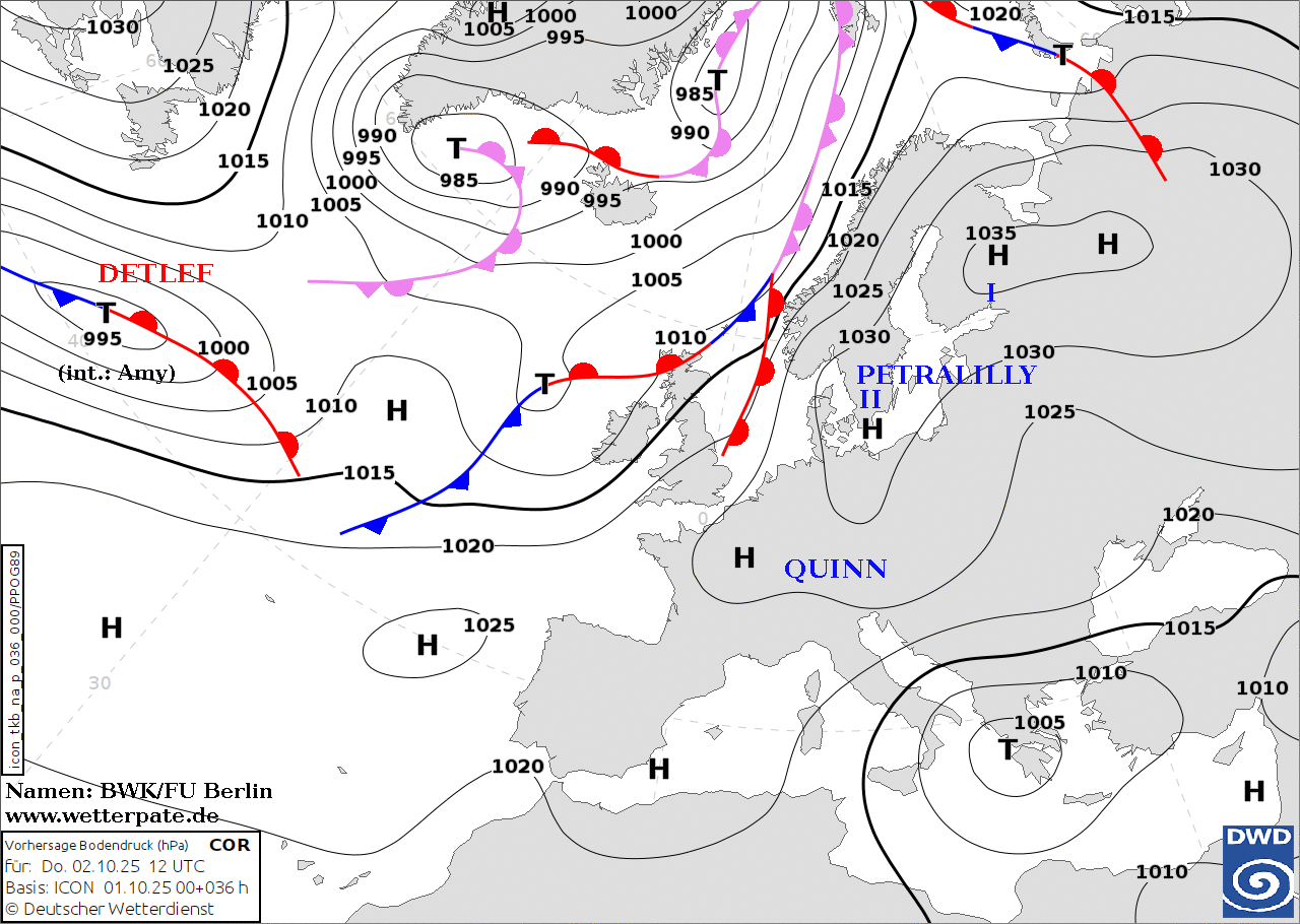
Storm Amy (Detlef)
| Storm Amy (Detlef) | |
|---|---|
| Area affected | United Kingdom, Ireland, Norway, Denmark, Sweden |
| Date of impact | 2-6 October 2025 |
| Maximum wind gust | 139 mph (62 m/s; 121 kn; 224 km/h) at Folgefonna, Norway |
| Lowest pressure | 942 hPa (27.82 inHg) |
| Fatalities | 4 |
| Power outages | 559,665+ |
Date Named & Background
Amy, known as Detlef in Germany was the first storm named by the Western Group (Met Office) on 1 October. A powerful "weather bomb," it reached a peak intensity of 942 hPa and produced a 139 mph gust at Folgefonna, Norway. The storm caused widespread damage and four deaths across France, Ireland, and Poland. Over 832,000 homes lost power across Northern Europe, with Sweden reporting its worst outages since 2019.,[25][26][27][28]
Weather Warnings Issued
Chief Meteorologist Tom Crabtree says, the system would bring gale force winds across northern and island areas of Scotland, with gusts widely reaching 50 to 60 miles per hour (22 to 27 m/s; 43 to 52 kn; 80 to 97 km/h) inland in the Caithness, Sutherland, and Hebrides areas, and potentially reaching 70 to 80 miles per hour (31 to 36 m/s; 61 to 70 kn; 110 to 130 km/h) in places. A yellow rain warning was in force for western and central parts of Scotland as 20–30 mm (0.79–1.18 in) of rain was expected widely in a 6-9 hour period with 40–50 mm (1.6–2.0 in) over some hilly areas in the Southwest and the Southern Highlands. Accompanying this was a large yellow wind warning for Scotland, which was upgraded to an Amber warning in northwestern parts of Scotland as well as western parts of Northern Ireland. A yellow wind warning from northern and western England, stretching down to north Wales, was in force with another wind warning in force for Northern Ireland, an area where 60–70 miles per hour (27–31 m/s; 52–61 kn; 97–113 km/h) winds where expected widely with 80 miles per hour (36 m/s; 70 kn; 130 km/h) and above expected in exposed areas. A yellow wind warning was later issued, covering the rest of south-west, central, southern, south-eastern and eastern England, as well as southern Wales, with gusts of 45–55 mph (20–25 m/s; 39–48 kn; 72–89 km/h) possible in places, and perhaps 60–65 mph (27–29 m/s; 52–56 kn; 97–105 km/h) along some exposed coasts.[29]
For Ireland a yellow wind warning was in place for the whole country, with the main cause for concern for Met Éireann being difficult travelling conditions, debris and loose objects displaced, and some fallen trees possible. A man in his forties died in the town of Letterkenny in County Donegal around 16:15 on October 3rd.[30]
For parts of southern and western Norway, red-severity warnings for extremely strong wind gusts along the Skagerrak coast and extremely heavy rain in parts of Telemark and Vestfold. Widespread orange-severity warnings were also in effect for very strong winds, very heavy rain, flooding, and the potential for debris avalanches and debris flows across various parts of the region. These will result in an expected high risk of cancelled flights, ferries and other transport disruptions.[31]
Danish Meteorological Institute issued warnings for high winds, heavy rain, and elevated water levels this weekend due to Storm Amy. Gale-force to stormy-gale winds, with hurricane-force gusts possible, were expected sweep the region, mainly on Jutland's coasts. Simultaneously, widespread heavy rain is expected Saturday, potentially dropping 40–60 mm (1.6–2.4 in) in some spots. High water levels up to 3.0 m (9.8 ft) were anticipated in the Wadden Sea and along the west coast of Jutland.[32]
Storm Impacts
In France two people have died due to the storm, the first one drowned and the second got killed in his car with a collapsed tree and second person was injured. [33]
In Scotland, a gust of 96 mph (43 m/s; 83 kn; 154 km/h) was recorded on Tiree whilst power cuts were reported in the Highlands. In Glasgow, a derelict building collapsed onto a car amid high winds on Broomielaw, forcing the road to close. A train travelling between Aberdeen and Inverurie hit a fallen tree, leaving around a dozen passengers stranded on the train. The Forth Road Bridge was closed, whilst high-sided vehicles were expected to be prevented from crossing the Clackmannanshire Bridge, Kincardine Bridge, Tyne Bridge and possibly the Queensferry Crossing. The Highland, Kyle, West Highland and Wick railway lines were closed and speed restrictions were placed on all Scottish routes, whilst many ferries from Cairnryan Harbour to Northern Ireland were cancelled.[34]
In Wales, around 600 properties lost power in Carmarthenshire and the Severn Bridge was closed in both directions. A fallen tree near Gobowen forced rail services to be suspended between Shrewsbury and Wrexham.[35]
Storm Barbara
| Storm Barbara | |
|---|---|
| Area affected | Italy, the Balkans, Turkey, Romania, Moldova, Ukraine |
| Date of impact | 5-10 October 2025 |
| Maximum wind gust | Unspecified |
| Lowest pressure | 1,003 hPa (29.62 inHg) |
| Fatalities | 0 |
| Power outages | Unspecified |
Date Named & Background
Part of the Central Mediterranean Group's list, Storm Barbara followed shortly after Amy. It brought unsettled weather to the Mediterranean basin, particularly affecting Italy and the Balkan Peninsula, contributing to the season's early total of fatalities..[14]
Weather Warnings Issued
Italy had orange wind warnings for the east coast south and not including San Marino to the heel of Italy. Further afield, red wind warnings were in force for the Velebit channel region of Croatia as well as orange rain warnings for surrounding inland parts of the country. Orange rain and wind warnings were in force for most areas in Montenegro.[36] Elsewhere, yellow rain warnings were inforce for parts of Slovenia, Bosnia and Herzegovina and Serbia.[37][38]
Orange rain warnings were put up for Bulgaria, with the east of the country having red rain warnings as well as south-eastern Romania.[39] Red rain warnings were also inforce for parts of Romania, Moldova and south-western Ukraine.[40][41]
Storm Impacts
The system brought record-breaking rainfall to Romania and Greece. Bucharest recorded its wettest October day in history during this event.[42][43]
Storm Alice
| Storm Alice | |
|---|---|
| Area affected | Eastern Spain and Balearic Islands |
| Date of impact | 7-10 October 2025 |
| Maximum wind gust | Unspecified |
| Lowest pressure | 1,015 hPa (29.97 inHg) |
| Fatalities | 0 |
| Power outages | Unspecified |
Date Named & Background
Alice, named on the 7 October 2025 was the first name used from the South-Western Group's list for the 2025–26 season. The system targeted the Iberian Peninsula, bringing heavy rain and wind to Portugal and Spain. A very small and weak area of low pressure known locally as a DANA.[9]
Weather Warnings Issued
Alice was a very small and weak area of low pressure that formed over the Iberian Peninsula near the Strait of Gibraltar that prompted the AEMET to issue amber and yellow warnings for rain for the southern Balearic Islands and eastern Spain. On the morning of 10 October, Spain issued an 'extreme risk' red weather warning for rain and flooding in Alicante and Murcia, Spain.[44]
Storm Impacts
It caused widespread flooding, with flights cancelled into Murcia.[45]
Storm Benjamin (Joshua)
| Storm Benjamin | |
|---|---|
| Area affected | United Kingdom, France, Spain, Netherlands, Belgium, Germany, Norway |
| Date of impact | 22-26 October 2025 |
| Maximum wind gust | 104 mph (46 m/s; 90 kn; 167 km/h)[46] |
| Lowest pressure | 969 hPa (28.61 inHg) |
| Fatalities | 2[47] |
| Power outages | Unspecified |
Date Named & Background
Named by Météo-France on 22 October, Benjamin, known as Joshua by the FUB was a significant system that affected a broad area from France and Spain to the UK and Norway. It attained a minimum pressure of 969 hPa and produced wind gusts up to 100 mph. The storm caused notable travel disruptions and structural damage across Western Europe..[9][48]
Weather Warnings Issued
Met Office issued yellow warnings for rain and wind across many parts of Southern England and Wales.[49] Météo-France placed orange warnings for wind, wave and rain-flood.[50] Belgium and the Netherlands also issued orange wind warnings for coastal areas. [51] AEMET issued a red alert for stormy seas for sections of the northern Spanish coast.[52]
Storm Impacts
The storm resulted in at least two fatalities and hundreds of millions of euros in insured losses. In France, wind gusts peaking at 104 mph (168 km/h) caused over 140,000 households to lose power, while a 45-year-old tourist was swept away by a river in Corsica. Additionally, 16 people were injured across the Charente-Maritime and Gironde departments, and a related tornado north of Paris in Val-d’Oise killed one person and critically injured four others after toppling construction cranes and uprooting trees. Travel across the continent was crippled, with Amsterdam Schiphol Airport cancelling more than 200 flights and London Heathrow reporting dozens of cancellations. The aviation disruption affected over 32,000 passengers at Schiphol alone, as safety protocols restricted operations to a single runway. In the Netherlands and the UK, fallen trees and downed power lines halted train services between major cities like Amsterdam, Rotterdam, and London, while ferry crossings in the English Channel were suspended due to treacherous maritime conditions. Infrastructure damage was extensive, with local flooding submerged roadways and coastal erosion damaging tourist sites like the Dune du Pilat. In the UK, more than 2,000 homes lost power, and heavy rainfall led to over a dozen rivers overflowing their banks, causing localised flooding in eastern and southern counties. As the storm system moved toward the North Sea, it pulled in a mass of Arctic air that resulted in a sharp temperature crash and the season's first significant snowfall in the Scottish Highlands.[53][54][55][56][57]
Storm Lothar
| Storm Lothar | |
|---|---|
| Area affected | United Kingdom, France, Spain, Netherlands, Belgium, Germany, Norway, Sweden, Poland, Lithuania, Latvia, Estonia |
| Date of impact | 26-31 October 2025 |
| Maximum wind gust | Unspecified |
| Lowest pressure | 988 hPa (29.18 inHg) |
| Power outages | Unspecified |
Date Named & Background
Named by the Free University of Berlin (FUB), Lothar tracked across a wide swath of Europe, including the UK, France, Germany, and the Baltic states. It brought a prolonged period of gale-force winds and heavy rain to Northern and Central Europe, resulting in localised flooding.[58]
Weather Warnings Issued
Storm Lothar, when weak, passed over Scotland, as a shallow low on 29 October, bringing heavy rain to parts of south-eastern England and northern and eastern France, prompting yellow rain/flood warnings for central-eastern parts of the country.[59] Deutscher Wetterdienst issued orange wind warnings for north-western provinces bordering Denmark. A yellow wind warning was also issued for north-western areas of Germany.[60] The next day on 30 October, Deutscher Wetterdienst expanded orange wind warnings to cover northern and eastern parts of the country, with a red offshore wind warning for north-west Poland.
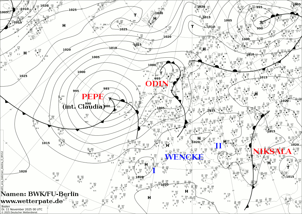
Storm Claudia (Pepe)
| Storm Claudia | |
|---|---|
| Area affected | United Kingdom, Ireland, Spain, Portugal |
| Date of impact | 10-17 November 2025 |
| Maximum wind gust | Unspecified |
| Lowest pressure | 970 hPa (28.64 inHg) |
| Fatalities | 3[61] |
| Power outages | Unspecified |
Date Named & Background
Named by AEMET on 10 November, Claudia, known as Pepe by FUB, made landfall in Western Europe with significant impact. The storm was particularly deadly in southern Portugal, where at least three people were killed and dozens were injured. It later moved across the UK and Ireland on 14 November, particularly impacting Wales.[9][62]
Weather Warnings Issued
Spain and Portugal experienced the most intense effects and subsequent warnings from Storm Claudia, which centered over the Iberian Peninsula and the Canary Islands. Portugal's IPMA had issued widespread Yellow Warnings for Rain, Strong Winds (up to 80–90 km/h, 22–25 m/s, 43–49 kn, 50–56 mph gusts), and Rough Seas across the mainland, particularly affecting coastal and northern districts. The Madeira Archipelago was placed under an Orange Warning for heavy rain and thunderstorms. In the coast of Fernão Ferro, a couple in their 80s was found dead in their flooded home.[63] In Spain, AEMET implemented Orange Alerts for the Canary Islands, specifically La Palma, due to the high risk of flooding from torrential rain (forecasted up to 100 mm or 3.9 in). Widespread Yellow Alerts were in place across the archipelago for heavy rain and gusty winds, and Yellow Alerts were also issued for heavy rainfall and winds up to 80 km/h (22 m/s; 43 kn; 50 mph) in the mainland's northwest, particularly in Galicia.[64][65]
The United Kingdom and Ireland felt the influence of an associated frontal system trailing Claudia. The Met Office issued a joint Yellow Rain and Wind Warning for South West England (including Cornwall, Devon, and Somerset), where heavy rain was expected to accumulate significantly (up to 60–80 mm (2.4–3.1 in) over exposed high ground), accompanied by strong southerly winds and coastal gales, leading to difficult driving conditions and localised flooding. Furthermore, Met Éireann had issued Status Yellow Rain Warnings for various counties in the south and east of Ireland, and the UK Met Office maintained Yellow Rain Warnings for Northern Ireland due to persistent rain and stronger winds along the Irish Sea coastlines.[66]
On 13 November, the Met Office issued a severe Amber Rain Warning for 14 November, covering large areas of Wales, the Midlands, western East Anglia, and South West England due to Storm Claudia. The key impacts of this high-level alert include a risk of danger to life from fast-flowing floodwater, homes and businesses being flooded, widespread travel cancellations and delays (especially on road and rail), and the potential for some communities to be cut off by floodwater. Rainfall was expected to be exceptional, with totals of 50–150 mm (2.0–5.9 in) possible across the affected areas.[67] Also, Met Éireann issued an Orange Rain Warning for three eastern counties: Dublin, Wexford, and Wicklow. This high-level warning signifies a significant risk of severe and dangerous flooding due to exceptionally high rainfall totals falling on already saturated ground, leading to extremely hazardous driving conditions and major travel disruption across these areas.[68]
Storm Impacts
As of 22:15 on 14 November, Environment Agency has issued more than 150 flood alerts and 39 flood warnings.[69] Two men have been taken to hospital after a head-on crash in a Black Country residential street.[70] Rail services across central and southern areas, including the lines between London Paddington and Bristol/South Wales, and routes in the Midlands (like around Birmingham New Street), have experienced major disruption and cancellations due to flooded tracks, with some passengers advised not to travel. Gusty winds, up to 70 mph (31 m/s; 61 kn; 110 km/h) in parts of North West England and North West Wales, have added to the hazardous conditions. There have been reports of power cuts and road closures due to flooding and fallen trees, with conditions expected to remain difficult until the rain eases on Saturday morning.[71][72][73]
Storm Claudia caused significant weather impacts across Ireland, with the main concern being widespread flooding expected to persist through the weekend. The Status Orange Rain Warning for Dublin, Wexford, and Wicklow has led to hazardous travelling conditions, numerous road closures due to debris and flooding (including in Dublin), and the cancellation of several flights at Dublin Airport. Areas under the broader Yellow warning have also seen significant local flooding, particularly in the Laois/Offaly region.[74] A major incident was declared in South Wales due to "severe and widespread" flooding in Monmouth.[75]
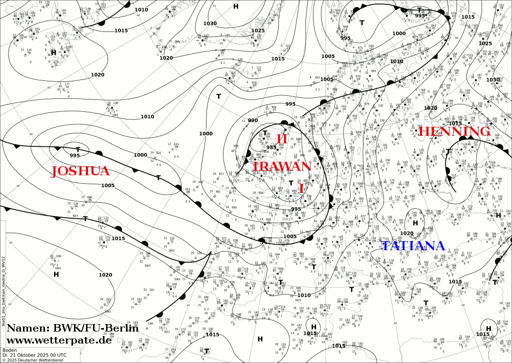
Storm Wolfgang
| Storm Wolfgang | |
|---|---|
| Area affected | Italy, the Balkans, Poland, Latvia |
| Date of impact | 24-27 November 2025 |
| Maximum wind gust | Unspecified |
| Lowest pressure | 997 hPa (29.44 inHg) |
| Power outages | Unspecified |
Date Named & Background
Wolfgang was a FUB-named system named on 24 November, that primarily affected Central Europe, including Germany and Poland. It contributed to the unsettled late-autumn pattern, bringing the first significant mountain snows of the season to the Alps and Tatras.[76]
Weather Warnings Issued
The Central Mediterranean and Western Balkans was severely impacted by a low-pressure system during that period, with a dangerous Red Rain Warning having been in effect for Tuesday, November 25th, in Campania, Italy, which included the region of Naples.[77] This Red alert signified a rare, extremely dangerous, and destructive weather event with the highest risk of life-threatening flash flooding, landslides, and major infrastructure damage. Simultaneously, the region was broadly affected by Orange Warnings primarily for heavy rain along the Adriatic coast of Croatia and across large parts of Southern Italy for rain, wind, and thunderstorms, where strong to gale-force south-easterly winds caused very rough seas with wind gusts reaching up to 95 km/h (26 m/s; 51 kn; 59 mph).[78] Broader Yellow Rain and Wind Warnings covered Slovenia, Bosnia and Herzegovina, and Montenegro, where heavy, persistent rainfall and strong winds caused travel difficulties and localised flooding.[79] Poland had issued an Orange/Level 2 warnings for heavy snowfall through central regions in Poland. Latvia had an Orange snow warning in force for central and eastern parts of the country.[80][81]
Storm Adel
| Storm Adel | |
|---|---|
| Area affected | Italy, Greece, Albania, Turkey |
| Date of impact | 25-30 November 2025 |
| Maximum wind gust | Unspecified |
| Lowest pressure | 1,004 hPa (29.65 inHg) |
| Power outages | Unspecified |
Date Named & Background
As the first name on the Eastern Mediterranean Group's list, Adel, named by the Hellenic National Meteorological Service on 25 November 2025, impacted Greece, Albania, and Turkey [2.1]. The storm brought heavy rain and thunderstorms to the region, leading to localized flash flooding.[82]
Weather Warnings Issued
Storm Adel formed quickly behind Storm Wolfgang, forecasted to bring heavy rainfall to Central Italy, and parts of Greece, Albania and western Turkey from 26–28 November 2025. On Thursday (27 November) Greece's Metservice warned of heavy rains and storms in the Ionian Islands, Epirus, western and central Sterea, western and southern Peloponnese, central and eastern Macedonia and Thrace. Then again on Friday (28 November) heavy rains and storms are expected in central and eastern Macedonia, Thrace, the eastern Aegean and until early morning in western Greece.[83] Italy, once again issued a red rain warning for Campania, which was impacted a few days prior by Wolfgang, a storm named by the Free University of Berlin that impacted the wider region on 24 November.[84]
Storm Impacts
The storm caused flooding in Corfu and Aetoloacarnania and as a result the schools were closed.[85] Extensive damages also took place in Thasos and Epirus, while damages also occurred in Attica.[86] The highest rainfall was recorded in Theodoriana, at 264 mm (10.4 in), and Pramanta, at 238 mm (9.4 in).[87]
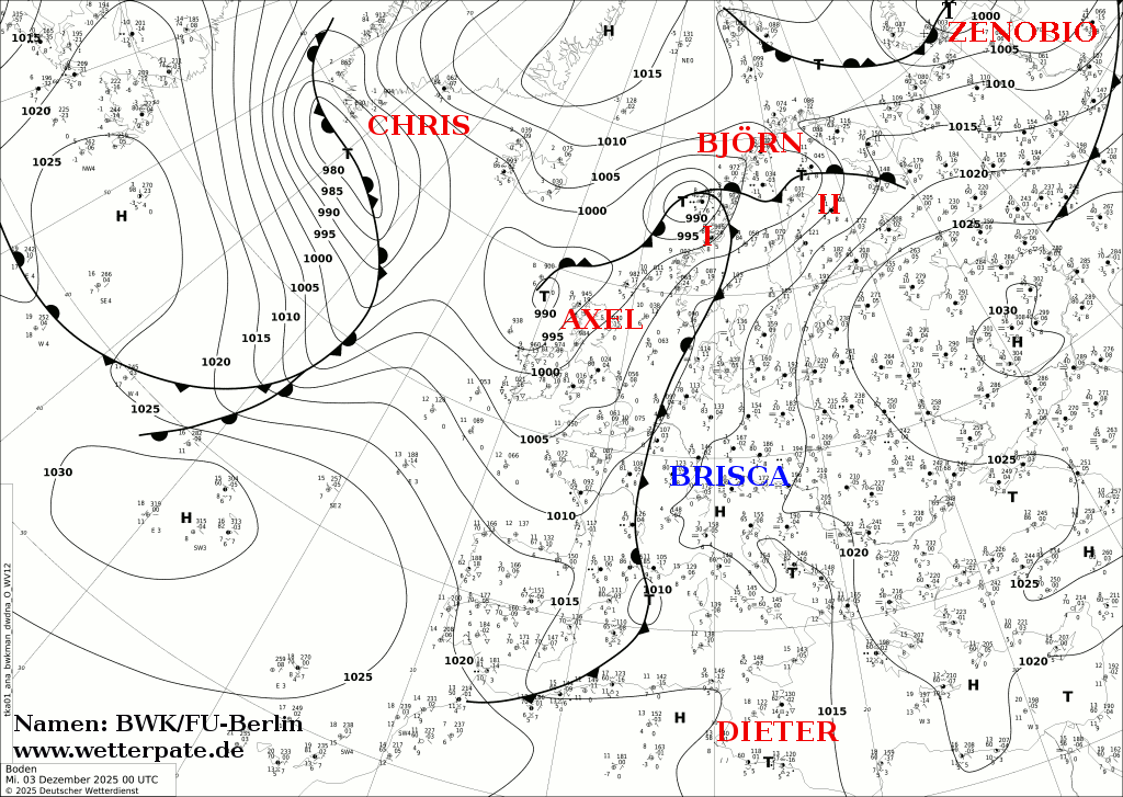
Storm Cassio (Dieter I)
| Storm Cassio | |
|---|---|
| Area affected | Italy, Bosnia and Herzegovina, Croatia, Austria |
| Date of impact | 3-5 December 2025 |
| Maximum wind gust | Unspecified |
| Lowest pressure | 999 hPa (29.50 inHg) |
| Fatalities | Unspecified |
| Power outages | Unspecified |
Date Named & Background
Named by the Central Mediterranean Group (Italy) and Dieter I by the Free University of Berlin, Cassio affected Italy, Croatia, and Austria. It brought heavy snowfall to the Dinaric Alps and high winds to the Adriatic coast.[88][9][89][90]
Weather Warnings Issued
The highest Italian alerts included Red and Orange warnings for catastrophic flooding and landslides across Emilia-Romagna, Liguria, and Tuscany, which was forecast to cause widespread damage to infrastructure and necessitating evacuations.[91]
Storm Impacts
The influence of Cassio extended across the Adriatic Sea to Croatia. While Italy's alerts focused on flooding, Croatia's national service (DHMZ) issued high-level warnings, typically Orange or Red alerts for the Adriatic Coastal regions and Dalmatia. These warnings primarily targeted strong, gale-force winds (Bura or Jugo) and coastal marine hazards, which is expected to cause significant travel disruption, ferry cancellations, and dangerous wave conditions along the exposed coastline.[92]
Storm Byron (Dieter II)
| Storm Byron | |
|---|---|
| Area affected | Greece, Cyprus, Israel, Gaza, East Jerusalem |
| Date of impact | 4-9 December 2025 |
| Maximum wind gust | Unspecified |
| Lowest pressure | 1,000 hPa (29.53 inHg) |
| Fatalities | 18+[93][94][95][96] |
| Power outages | Unspecified |
Date Named & Background
Byron or Biron[97] was named by the Eastern Mediterranean Group (Greece). It primarily affected Greece, Cyprus, and Israel. The system brought significant precipitation to the Levant, causing flooding in Gaza and East Jerusalem.[98] It was also named Dieter II by the Free University of Berlin.[99]
Weather Warnings Issued
In anticipation of the storm's extensive impact, the General Secretariat for Civil Protection in Greece issued a "Red Code" mobilization—the highest state of alert—for at least ten regional units, including Attica (Greater Athens), Thessaly, the Peloponnese, and numerous islands in the Aegean. As a preventative measure, authorities ordered the closure of all public and private schools across all educational levels on December 5, in high-risk areas, including the capital and islands like Rhodes and Santorini. Citizens in affected areas were strongly advised to restrict movement to essential travel and avoid basements or underground parking areas due to the high risk of flash flooding. Shipping routes in the Aegean Sea faced disruption and cancellations due to the forecast of wind speeds reaching up to 9 on the Beaufort scale.[100] A yellow rain warning was issued for all of Cyprus with 55 millimetres per hour, meaning total accumulation will likely exceed 55 millimetres over 24 hours, posing a significant risk of flash flooding.[101]
Storm Impacts
Byron caused flooding in the Gaza Strip and left at least 14 people dead, including three children.[102] At least 12 buildings already damaged due to Israeli bombing during the Gaza war partially collapsed in the territory.[96]
Storm Davide (Elias)
| Storm Davide | |
|---|---|
| Area affected | United Kingdom, France, Ireland |
| Date of impact | 5-7 December 2025 |
| Maximum wind gust | Unspecified |
| Lowest pressure | 965 hPa (28.50 inHg) |
| Fatalities | Unspecified |
| Power outages | Unspecified |
Date Named & Background
Named by the South-Western Group on 5 December 2025, Davide (Elias in Germany) brought further wind and rain to France and the Iberian Peninsula. It maintained a period of high-impact weather across south-western Europe[103][104]
Weather Warnings Issued
On 5 December, it brought severe gales through the English Channel and Irish Sea causing yellow warnings for wind for Ireland, Northern Ireland, northern coasts of France.[105] All of those areas, including southern English coasts were also under a force 9 severe gale warning.[106]
Storm Impacts
The North Wales coast, specifically from Llanddulas to the East coast of Anglesey and the North West coastline from the Menai Straits to Borth, was under a flood risk for two days due to a combination of high tides and adverse weather. Residents were urged to be careful near coastal paths, beaches, and estuaries. Simultaneously, the River Severn catchment area, from Newtown to the Severn-Vyrnwy Confluence, experienced expected flooding of low-lying land and roads following heavy rainfall that began on the afternoon of Friday 5 December, 2025. River levels were elevated, impacting roads near areas like Cilcewydd, Welshpool, and Llandrinio.[107]
Storm Davide had strong thunderstorms in its core due to a mix of very strong wind shear and strong pressure changes. This gave southern counties of England, hail and tornadic supercells on the night of 5 December and into December 6. A tornado tracked through a town called Seaford in East Sussex at around 03:40 GMT on 6 December.[108] The following TORRO analysis of the damage concluded that the tornado likely reached winds of over 95 mph (42 m/s; 83 kn; 153 km/h) and an intensity of T3 on the TORRO scale as it ripped several garage doors and roofs off along with several roof tiles along its track.[109]
Storm Bram (Helmut)
| Storm Bram | |
|---|---|
| Area affected | United Kingdom, Ireland |
| Date of impact | 8-11 December 2025 |
| Maximum wind gust | 96 mph (43 m/s; 83 kn; 154 km/h) at Elgol, Scotland |
| Lowest pressure | 959 hPa (28.32 inHg) |
| Power outages | Unspecified |
Date Named & Background
Named by the Met Éireann on 8 December, Bram, named Helmut by FUB, was the second storm of the season for the Western Group. It tracked across the UK and Ireland, producing significant wind gusts and travel disruption.[110][111]
Storm Bram was an extra-tropical cyclone, of a specific kind called a Shapiro-Keyser Cyclone.[112]
Weather Warnings Issued
Warnings were issued across the regions, including Amber Wind Warnings for northwest Scotland and Amber Rain Warnings for areas in south Wales and Devon. Ireland's Met Éireann also put Status Orange wind warnings in place for multiple coastal counties. The primary concern was the combination of extreme elements. Wind gusts were forecast to reach upwards of 90 mph (40 m/s; 78 kn; 140 km/h) in exposed coastal areas of Scotland, while widespread winds of 50–70 mph (22–31 m/s; 43–61 kn; 80–113 km/h) impacted the rest of the UK. Heavy rainfall was recorded, with some areas in south Wales and southwest England receiving up to 100 mm (3.9 in) of rain. These intense conditions caused severe disruption. The high wind and rain led to significant travel issues, with rail speed restrictions and widespread delays across air and ferry services. Due to the high rainfall on saturated ground, the storm increased the risk of flooding and local power cuts in many affected areas.[113][114] At around 17:00 GMT on 8 December, a red warning over the Irish waters between Loop Head and Malin Head was issued as force 11 violent storm force winds were expected between 12:00 and 23:30 GMT on 9 December. At around 21:00 GMT, this red warning was extended southwards to Mizen Head, and pushed forward to 09:00 GMT. As well as this, the orange warnings were extended to cover the majority of the whole of Ireland at the same time. [115] By 08:00 GMT on 9 December, the red warnings were further extended all the way around the coast to Carnsore Point and the orange warnings were extended over the rest of Ireland and most of Northern Ireland.[116]
Storm Impacts
White Barrow in Devon, recording 111.5 mm (4.39 in) of rainfall, Treherbert in Glamorgan had 83.8 mm (3.30 in), just ahead of Dartmoor (81.2 mm or 3.20 in) and Princetown (79.4 mm or 3.13 in) in Devon. Flights and trains were cancelled throughout Tuesday, and hundreds of properties left without power. The M4 Prince of Wales Bridge in Gloucestershire was not due to reopen until 06:00 due to emergency roadworks to allow for the removal of 35 faulty lighting columns at risk of collapse, which could've been impacted by the strong winds and heavy rain from Bram. Due to strong winds, the A66 in County Durham/Cumbria is closed to high-sided vehicles between the A1M (Scotch Corner) and M6 (Penrith). The A19 Tees Flyover was also closed. In Greater Manchester, the M66 southbound was closed for water clearance. For rail, Scotland's routes face ongoing disruption. Several routes closed by Storm Bram, including Fort William to Mallaig and Dingwall to Kyle of Lochalsh, require daylight inspection for damage before reopening.[117]
Storm Emilia (Jonathan)
| Storm Emilia | |
|---|---|
| Area affected | Spain, Canary Islands, Portugal, Morocco |
| Date of impact | 11-15 December 2025 |
| Maximum wind gust | 98 mph (44 m/s; 85 kn; 158 km/h) at Izaña, Canary Islands |
| Lowest pressure | 1,007 hPa (29.74 inHg) |
| Fatalities | 37+ |
| Power outages | Unspecified |
Date Named & Background
Emilia, was named by the South-Western Group and Jonathan by FUB. It brought severe weather to the Iberian Peninsula, Canary Islands and Morocco.[118]
Weather Warnings Issued
AEMET issued widespread Orange and Yellow alerts for Friday and Saturday across all Canary Islands due to severe conditions including high winds (up to 90 km/h, 25 m/s, 49 kn, 56 mph), heavy rain, snow, thunderstorms, and dangerous coastal conditions (waves up to 6–7 m or 20–23 ft).[119]
The Spanish weather agency, AEMET, issued a Red Alert for the Valencia coastline due to the threat of torrential rain (over 250 mm or 9.8 in expected) from Storm Emilia, indicating an extreme risk of severe flash flooding and danger to life.[120]
Morocco's weather authority has issued an Orange alert for heavy snowfall (up to 50 cm or 20 in) in Midelt, Ouarzazate, and Tinghir, along with significant snow (10–30 cm or 3.9–11.8 in) across several other regions, with rain and storms expected at lower altitudes (below 1,400 m or 4,600 ft) from Friday to Sunday.[121]
Storm Impacts
Storm Emilia caused catastrophic damage across the Canary Islands, Morocco, and Spain in mid-December 2025, resulting in at least 37 fatalities due to flash flooding in the Moroccan city of Safi.[122] In the Canary Islands, emergency services responded to a record 2,225 incidents as the archipelago was battered by hurricane-force gusts of 98 mph (44 m/s; 85 kn; 158 km/h) at Izaña and waves exceeding 9 meters. The storm brought unusual heavy snowfall[123] to the peaks of Tenerife and Gran Canaria, forcing the closure of Teide National Park, while torrential rains of up to 150 mm triggered mudslides and urban flooding across Murcia and Valencia on the Spanish mainland.[124]
Storm Nils
| Storm Nils | |
|---|---|
| Area affected | France, Spain, Italy, Croatia, Slovenia |
| Date of impact | 20-26 December 2025 |
| Maximum wind gust | Unspecified |
| Lowest pressure | 989 hPa (29.21 inHg) |
| Power outages | Unspecified |
Date Named & Background
Storm Nils was named by the Free University of Berlin on 20 December 2025.[125] It originated as a low off the coast of the British Isles, then split into Nils II on 22 December and tracked into the Mediterranean.[126]
Weather Warnings Issued
Orange warnings (Level 3) were active for high elevations in the Black Forest and Bavarian Alps, where wind gusts were expected to reach 80–100 km/h. These gale-force conditions are expected to persist through Christmas Eve, accompanied by additional hazards like freezing rain and icy roads.[127]
This system throughout it's life brought widespread orange warnings across Italy and other Mediterranean regions. On 24 December, locally strong winds and gales with strong gusts of 55-65 knots (100-120 km/h) were expected with peak gusts possibly up to hurricane force at 70 knots (130 km/h). This along with locally high waves were warned in both Croatia and Slovenia.[128][129]
Multiple orange warnings were issued in Italy for heavy rainfall, along with heavy snowfall at altitudes above 300-400 meters expected between 12:00 UTC on 24 December until 06:00 UTC on 26 December. The warnings also warned coastal regions of strong gales up to 40-50 knots (75-90 km/h) and strong storm surges.[130]
Season effects
Storm Type Key:
(EX: Extratropical Cyclone, Post-Tropical Cyclone, Genoa Low, Ionian Low)
(TC: Tropical Cyclone, Subtropical Cyclone (Medicane on Mediterranean)
(NC: Isolated Depression on High Altitude (DANA))
| Name | FUB name | Storm Type | Dates active | Highest wind gust | Lowest pressure | Named by | Countries affected | Fatalities (+missing) |
|---|---|---|---|---|---|---|---|---|
| Alessio | Calvin | Genoa Low | 20–24 September 2025 | Unspecified | 1,008 hPa (29.77 inHg) | Italy | Italy, Spain, Switzerland, Slovenia, Croatia | 2 |
| Gabrielle | N/A | Post-Tropical Cyclone | 25-29 September 2025 | Unspecified | 990 hPa (29.23 inHg) | NHC | Azores, Iberian Peninsula | Unspecified |
| Amy | Detlef | Extratropical Cyclone | 2-6 October 2025 | 139 mph (62 m/s; 121 kn; 224 km/h) | 942 hPa (27.82 inHg) | United Kingdom | United Kingdom, Ireland, Norway, Denmark, Sweden | 4 |
| Barbara | N/A | Genoa Low | 5-10 October 2025 | Unspecified | 1,003 hPa (29.62 inHg) | Italy | Italy, the Balkans, Romania, Moldova, Ukraine | Unspecified |
| Alice | N/A | DANA | 7-10 October 2025 | N/A | 1,015 hPa (29.97 inHg) | Spain | Eastern Spain and Balearic Islands | Unspecified |
| Benjamin | Joshua | Extratropical Cyclone | 22–26 October 2025 | 104 mph (46 m/s; 90 kn; 167 km/h) | 969 hPa (28.61 inHg) | France | United Kingdom, France, Spain, Netherlands, Belgium, Germany, Norway | 1 |
| Lothar | FUB assigned | Extratropical Cyclone | 26-31 October 2025 | Unspecified | 988 hPa (29.18 inHg) | Germany | United Kingdom, France, Spain, Netherlands, Belgium, Germany, Norway, Sweden, Poland, Lithuania, Latvia, Estonia | Unspecified |
| Claudia | Pepe | Extratropical Cyclone | 10-17 November 2025 | Unspecified | 970 hPa (28.64 inHg) | Spain | United Kingdom, Ireland, Spain, Portugal | 3 |
| Wolfgang | FUB assigned | Extratropical Cyclone | 24-27 November 2025 | Unspecified | 997 hPa (29.44 inHg) | Germany | Italy, the Balkans, Poland, Latvia | Unspecified |
| Adel | N/A | Genoa Low | 25-30 November 2025 | Unspecified | 1,004 hPa (29.65 inHg) | Greece | Italy, Greece, Albania, Turkey | Unspecified |
| Cassio | Dieter I | Extratropical Cyclone | 3-5 December 2025 | Unspecified | 999 hPa (29.50 inHg) | Italy | Italy, Bosnia and Herzegovina, Croatia, Austria | Unspecified |
| Byron | Dieter II | Extratropical Cyclone | 4-9 December 2025 | Unspecified | 1,000 hPa (29.53 inHg) | Greece | Greece, Cyprus, Israel | 18+ |
| Davide | Elias | Extratropical Cyclone | 5-7 December 2025 | Unspecified | 965 hPa (28.50 inHg) | France | United Kingdom, France, Ireland | Unspecified |
| Bram | Helmut | Extratropical Cyclone | 8-11 December 2025 | 96 mph (43 m/s; 83 kn; 154 km/h) | 959 hPa (28.32 inHg) | Ireland | United Kingdom, Ireland | Unspecified |
| Emilia | Jonathan | Extratropical Depression | 11-15 December 2025 | 98 mph (44 m/s; 85 kn; 158 km/h) | 1,007 hPa (29.74 inHg) | Spain | Spain, Canary Islands, Portugal, Morocco | 37+ |
| Nils | FUB Assigned | Extratropical Cyclone | 20-26 December 2025 | Unspecified | 989 hPa (29.21 inHg) | Germany | France, Spain, Italy, Croatia, Slovenia | Unspecified |
See also
- Weather of: 2025
- Tropical cyclones in: 2025, 2026
- 2025–26 North American winter
- 2025–26 Asian winter
References
- ^ "Weather Warnings Explanation". Met Éireann The Irish Meteorological Service. Met Éireann. Archived from the original on 19 February 2023. Retrieved 18 February 2023.
- ^ a b "UK Storm Centre". Met Office. UK Met Office. Archived from the original on 27 November 2021. Retrieved 18 February 2023.
- ^ "KNMI waarschuwingen" (in Dutch). KNMI. Archived from the original on 17 February 2023. Retrieved 19 February 2023.
- ^ Leitao, Paula; Roulet, Bernard; Rey, Jaime (September 2018). "Storm naming: the First Season of Naming by the South-west Group: Spain-Portugal-France" (PDF). The European Forecaster (Newsletter of the WGCEF) (23): 33–37. Archived from the original (PDF) on 2 January 2023. Retrieved 19 February 2023.
- ^ Kotroni, V.; Lagouvardos, K.; Bezes, A.; Dafis, S.; Galanaki, E.; Giannaros, C.; Giannaros, T.; Karagiannidis, A.; Koletsis, I.; Kopania, T.; Papagiannaki, K.; Papavasileiou, G.; Vafeiadis, V.; Vougioulas, E. (2021). "Storm Naming in the Eastern Mediterranean: Procedures, Events Review and Impact on the Citizens Risk Perception and Readiness". Atmosphere. 12 (11): 1537. Bibcode:2021Atmos..12.1537K. doi:10.3390/atmos12111537.
- ^ "Storms in Denmark since 1891" (PDF). dmi.dk. Retrieved 25 June 2023.
- ^ "Naming the Weather: Institute of Meteorology at Freie Universität Assigns Names to Weather Highs and Lows for the Year Ahead: Starting 25 September 2013". Freie Universität Berlin Office of Communication and Marketing. Freie Universität Berlin. 23 September 2013. Archived from the original on 9 February 2023. Retrieved 19 February 2023.
- ^ "UK Storm Centre". Met Office.
- ^ a b c d e "Borrascas y danas con gran impacto de la temporada 2025-2026". AEMET.
- ^ "Storm Naming, Denominazione delle tempeste | Meteo Aeronautica Militare". www.meteoam.it.
- ^ "Names of significant weather events for the 2025/26 season". GOV.IL. Retrieved 8 November 2025.
- ^ "Aktion Wetterpate". www.wetterpate.de. 2 October 2019.
- ^ a b O'Toole, Lauran (22 September 2025). "Horror in Barcelona as second body found after young boy and dad swept away". Express.
- ^ a b "Storm Naming, Denominazione delle tempeste | Meteo Aeronautica Militare". meteoam.it. 1 September 2024. Archived from the original on 1 September 2024.
- ^ G, J. A. (22 September 2025). "Young boy dies and adult still missing after torrential rain and flooding hits north of Spain". Sur in English.
- ^ Blake, Eric (17 December 2025). Tropical Cyclone Report: Hurricane Gabrielle (AL072025) (PDF) (Report). Miami, Florida: National Hurricane Center. Retrieved 19 December 2025.
- ^ Marshall, Hayden; Tonks, Sara (24 September 2025). "Hurricane Gabrielle Crossing The North Atlantic". The Weather Channel. Retrieved 24 September 2025.
- ^ "Ciclone Gabrielle coloca grupos Ocidental e Central dos Açores sob aviso vermelho da meteorologia" [Cyclone Gabrielle prompts western and central Azores under red alerts]. Açoriano Oriental. 24 September 2025. Retrieved 24 September 2025.
- ^ "Avisos de mau tempo sobem para laranja no Grupo Oriental". Açoriano Oriental. 25 September 2025. Retrieved 25 September 2025.
- ^ O'Toole, Lauran (28 September 2025). "British tourists travelling to Spain hotspot given 'red alert'". Express.
- ^ "Governo regional fecha escolas nos Açores devido a ciclone Gabrielle". RTP News (in Portuguese). 24 September 2025. Retrieved 24 September 2025.
- ^ "Portos da Madalena, Lajes e Horta fechados sexta-feira devido ao ciclone Gabrielle" [Ports of Madalena, Lajes, and Horta closed Friday due to Cyclone Gabrielle]. Açoriano Oriental. 24 September 2025. Retrieved 24 September 2025.
- ^ "Furacão Gabrielle: TAP e SATA alertam para eventuais constrangimentos nos voos". RTP Açores (in European Portuguese). 25 September 2025. Retrieved 25 September 2025.
- ^ "Red alert as hurricane approaches the Azores". www.theportugalnews.com.
- ^ Press Office (1 October 2025). "Storm Amy named". Met Office. Archived from the original on 2 October 2025. Retrieved 2 October 2025.
- ^ "Europe Weather Forecast Map on 1 October 2025". Deutscher Wetterdienst (Free University of Berlin) (in German). 1 October 2025. Archived from the original on 2 October 2025. Retrieved 2 October 2025.
- ^ King, Simon (1 October 2025). "Storm Amy named with 80mph winds and severe weather warnings for the UK". BBC. Retrieved 2 October 2025.
- ^ "Storm Amy: What to expect – Met Office Weather". 1 October 2025 – via YouTube.
- ^ "UK weather warnings". Met Office.
- ^ "Storm Amy: Man (40s) dies in storm-related incident as 184,000 remain without power; Met Éireann issue fresh Status Orange warnings". Irish Independent. 3 October 2025.
- ^ https://www.met.no/nyhetsarkiv/ekstremvaeret-amy-ekstremt-kraftige-vindkast-og-regn
- ^ "Meteorologens kommentar". www.dmi.dk.
- ^ "Storm Amy kills two in France as powerful winds put nation on alert". France 24. 4 October 2025.
- ^ "Storm Amy danger warnings as 100 mph (45 m/s; 87 kn; 160 km/h) gusts recorded". BBC News. 3 October 2025. Retrieved 3 October 2025.
- ^ Hoskin, Rowenna (3 October 2025). "Rail services halted by fallen tree as Storm Amy hits". BBC News. Retrieved 3 October 2025.
- ^ "ZHMS". www.meteo.co.me. Archived from the original on 22 April 2025. Retrieved 8 November 2025.
- ^ "meteo.si - Uradna vremenska napoved za Slovenijo - Državna meteorološka služba RS - Opozorila". meteo.arso.gov.si.
- ^ "Republic Hydrometeorological Service of Serbia Kneza Višeslava 66 Beograd::::::::::::::::::::::::::::::::::::::::::::::::::::::". www.meteoalarm.rs.
- ^ "Опасни явления по общини и области". www.weather.bg.
- ^ "AB".
- ^ "Meteorological. UHMC". UHMC.
- ^ https://www.tovima.com/society/storm-barbara-brings-heavy-rain-and-strong-winds-to-greece/
- ^ https://www.romania-insider.com/romania-record-levels-precipitation-cyclone-barbara-october-2025
- ^ "Storm Alice: Spain issues 'extreme risk' red weather warning for Costa Blanca | ITV News". ITV News. 10 October 2025. Archived from the original on 11 October 2025. Retrieved 8 November 2025.
- ^ https://www.bbc.co.uk/weather/articles/c8ex0grwxw0o
- ^ "Hundreds of thousands without power in France – Storm Benjamin sweeps across Europe". Weather & Radar. 24 October 2025.
- ^ "Daily Flash". erccportal.jrc.ec.europa.eu.
- ^ https://www.met.fu-berlin.de/de/wetter/maps/Analyse_20251021.gif
- ^ https://x.com/metoffice/status/1980619053862359183
- ^ "Tempête Benjamin : fort coup de vent sur le pays dès mercredi soir" (in French).
- ^ "Authorities warn of hazardous travel as storm Benjamin set to hit Western provinces". NL Times. 22 October 2025.
- ^ Carter, Humphrey (22 October 2025). "Storm Benjamin will trigger red alerts as 8-metre waves batter Spain as it heads towards the Balearics". Majorca Daily Bulletin.
- ^ https://evrimagaci.org/gpt/storm-benjamin-hammers-europe-with-fierce-winds-and-chaos-513110
- ^ https://english.news.cn/20251023/48ed0a6d962344749e4e9928b3f05751/c.html
- ^ https://reliefweb.int/report/france/france-england-severe-weather-met-office-meteo-france-media-echo-daily-flash-24-october-2025
- ^ https://www.insuranceday.com/ID1154910/Storm-Benjamin-losses-may-reach-several-hundred-millions-euros-Aon
- ^ https://www.theguardian.com/world/2025/oct/24/weather-tracker-tornadoes-and-storm-benjamin-lash-northern-france
- ^ https://page.met.fu-berlin.de/wetterpate/static/archiv/2025/Analyse_20251026.gif
- ^ "VIGILANCE METEO SAÔNE-ET-LOIRE (71) par Météo-France". vigilance.meteofrance.fr.
- ^ "MeteoAlarm | Early Warnings for Europe".
- ^ https://erccportal.jrc.ec.europa.eu/ECHO-Products/Echo-Flash#/daily-flash-archive/5475
- ^ https://www.met.fu-berlin.de/de/wetter/maps/Analyse_20251111.gif
- ^ "Two dead as Storm Claudia ravages Portugal". News.az. Retrieved 13 November 2025.
- ^ "IPMA - Weather warnings in timeline". IPMA.
- ^ "Meteorological warnings". AEMET.
- ^ "UK weather warnings". Met Office.
- ^ https://weather.metoffice.gov.uk/warnings-and-advice/uk-warnings#?date=2025-11-14&id=a8365926-d594-43ff-a16d-ba3d9b806745
- ^ https://www.met.ie/forecasts/meteorologists-commentary
- ^ https://www.independent.co.uk/news/uk/home-news/storm-claudia-uk-weather-warnings-flooding-latest-b2864920.html
- ^ https://uk.news.yahoo.com/two-injured-head-crash-walsall-203324502.html
- ^ https://www.theguardian.com/uk-news/2025/nov/14/storm-claudia-torrential-rain-england-wales-weather#:~:text=The%20Met%20Office%20said%20there,into%20Saturday%20will%20be%20soaked.
- ^ https://www.itv.com/news/central/2025-11-14/how-will-the-midlands-be-affected-by-storm-claudia
- ^ https://news.sky.com/story/uk-weather-flood-and-do-not-travel-warnings-issued-as-storm-claudia-arrives-13469515#:~:text=The%20rain%20is%20the%20main,England%2C%20the%20Met%20Office%20said.
- ^ https://www.irishtimes.com/environment/2025/11/14/live-coverage-ireland-weather-rainfall-orange-warnings/
- ^ https://news.sky.com/story/storm-claudia-latest-significant-risk-to-life-warnings-issued-due-to-severe-flooding-13470641
- ^ https://page.met.fu-berlin.de/wetterpate/static/archiv/2025/Analyse_20251124.gif
- ^ https://www.accuweather.com/en/it/naples/212466/weather-warnings/212466
- ^ https://meteo.hr/naslovnica-upozorenja.php?lang=en&tab=upozorenja
- ^ https://www.accuweather.com/en/it/amalfi/212365/weather-warnings/212365
- ^ https://meteo.imgw.pl/dyn/index.html#osmet=true&oshyd=false&pronieb=false&roadwarn=false&pnzh=false&model=alaro4k0&loc=52.24,21.034,7
- ^ https://bridinajumi.meteo.lv/
- ^ https://www.meteoam.it/it/storm-naming
- ^ https://emy.gr/warnings?tab=deterioration
- ^ https://page.met.fu-berlin.de/wetterpate/static/archiv/2025/Analyse_20251124.gif
- ^ CARASSAVA, ANTHEE (27 November 2025). "Storm Adel Batters Western Greece; Floods Close Schools and Ground Flights". iefimerida.gr (in Greek). Retrieved 27 November 2025.
- ^ "Δοκιμάστηκαν περιοχές από την κακοκαιρία - Πλημμύρες και καθιζήσεις". ertnews.gr (in Greek). 29 November 2025. Retrieved 1 December 2025.
- ^ Petrou, John; Moustris, Alec. "Αθροιστικά ύψη βροχής 4 ημερών έως το πρωι του Σαββάτου 29/11 - Ξεπέρασε τα 250 mm το ύψος βροχής στα Τζουμέρκα". meteo.gr (in Greek). meteo.gr. Retrieved 1 December 2025.
- ^ https://www.meteoam.it/it/storm-naming
- ^ https://www.met.fu-berlin.de/de/wetter/maps/Analyse_20251203.gif
- ^ https://page.met.fu-berlin.de/wetterpate/static/archiv/2025/Analyse_20251205.gif
- ^ https://meteoalarm.org/en/live/warning/449de13c-39e5-498a-9803-8d238dec272c/13192a3f-4ffe-467d-b8a6-4d560d46dac7?s=puglia
- ^ https://meteo.hr/naslovnica-upozorenja.php?tab=upozorenja
- ^ Isaacson, Gila (8 December 2025). "Storm Byron Heads to Israel After Devastating Greece: Heavy Rains, Flood Risks Loom". Jfeed. Retrieved 17 December 2025.
- ^ "Man found dead in Netanya, apparently suffered from hypothermia". Ynet. 11 December 2025. Retrieved 12 December 2025.
- ^ "Man found lifeless with signs of hypothermia in puddle in Jerusalem". Ynet. 12 December 2025. Retrieved 12 December 2025.
- ^ a b "14 Palestinians killed as storm Byron hits Gaza". Pajhwok Afghan News. 12 December 2025. Retrieved 13 December 2025.
- ^ https://ims.gov.il/en/node/2796?type=
- ^ https://page.met.fu-berlin.de/wetterpate/static/archiv/2025/Analyse_20251201.gif
- ^ https://page.met.fu-berlin.de/wetterpate/static/archiv/2025/Analyse_20251205.gif
- ^ Carassava, Anthee (4 December 2025). "Storm Byron Lashes Greece; 'Red Alerts' Issued for 48-Hour Deluge". Efimerida ton Syntakton. Retrieved 17 December 2025.
- ^ https://meteoalarm.org/el/live/region/CY
- ^ Dahman, Ibrahim; Kourdi, Eyad; Salem, Mostafa (13 December 2025). "Gaza storms kill 14 Palestinians, including 3 children". CNN. Retrieved 22 December 2025.
- ^ Meteorología, Agencia Estatal de. "Borrascas y danas con gran impacto de la temporada 2025-2026 - Agencia Estatal de Meteorología - AEMET. Gobierno de España". www.aemet.es (in Spanish). Retrieved 16 December 2025.
- ^ https://page.met.fu-berlin.de/wetterpate/static/archiv/2025/Prognose_20251205.gif
- ^ https://weather.metoffice.gov.uk/warnings-and-advice/uk-warnings#?date=2025-12-05&id=9ec8a8c4-7380-4b17-b811-9051f76328d9
- ^ https://weather.metoffice.gov.uk/specialist-forecasts/coast-and-sea/shipping-forecast
- ^ https://www.dailypost.co.uk/news/north-wales-news/live-travel-updates-flood-alerts-33011274
- ^ https://www.bbc.co.uk/news/articles/crmde2n3r3vo
- ^ https://www.facebook.com/TorroUK/posts/following-one-of-our-site-investigators-visiting-seaford-east-sussex-yesterday-t/1258358032994991/&sa=U&ved=2ahUKEwiJvMrusr-RAxVtUqQEHRaqJP0QFnoECAoQAg&usg=AOvVaw22MOLd07L7VC2OC-d75-m3&fexp=73217441,73217442
- ^ Met Office (8 December 2025). "Storm Bram has been named". metoffice.gov.uk.
- ^ "Prognose 20251207". Institut für Meteorologie: Fachbereich Geowissenschaften. 7 December 2025.
- ^ "Met Office Deep Dive: Warnings still in place as Storm Bram's impacts felt". Met Office. 10 December 2025. Retrieved 10 December 2025.
- ^ "UK weather warnings". Met Office.
- ^ "Storm Bram bringing very strong winds and heavy rain". An Roinn Tithíochta, Rialtais Áitiúil agus Oidhreachta: Met Éireann.
- ^ "Warnings and Advisories - Amárach Dé Máirt 09 Nollaig 2025". An Roinn Tithíochta, Rialtais Áitiúil agus Oidhreachta: Met Éireann.
- ^ "Warnings and Advisories - Today Monday 22 December 2025". Met Éireann.
- ^ "Storm Bram brings 90mph winds, rain and flooding to parts of UK". Sky News. 10 December 2025.
- ^ "Borrascas y danas con gran impacto de la temporada 2025-2026" (in Spanish).
- ^ "STORM EMILIA TO BATTER THE CANARIES WITH HEAVY RAIN, GALE-FORCE WINDS, ROUGH SEAS, THUNDERSTORMS AND SNOW". Canarian Weekly. 11 December 2025.
- ^ https://www.aemet.es/en/eltiempo/prediccion/destacados/p5_t?tipo=p52tesp1
- ^ "Several provinces across Morocco to face snow, heavy rains this weekend". Hespress. 11 December 2025.
- ^ "Storm Emilia suspends Moroccan fresh produce exports". Fresh Plaza. Retrieved 22 December 2025.
- ^ "Storm Emilia hits Gran Canaria with force: heavy rain, wind and snow at the summit, with the first rains reaching reservoirs and ravines". Masapalomas24h.uk. 14 December 2025.
- ^ "Incident Record in the Canary Islands: Storm Emilia Triggers 2,225 Emergency Responses". Tenerife Weekly. 15 December 2025.
- ^ https://page.met.fu-berlin.de/wetterpate/static/archiv/2025/Analyse_20251222.gif
- ^ https://page.met.fu-berlin.de/wetterpate/static/anabwkna.gif
- ^ https://www.dwd.de/DE/wetter/warnungen_landkreise/warnWetter_node.html
- ^ https://meteo.hr/naslovnica-upozorenja.php?lang=en&tab=upozorenja
- ^ https://meteo.arso.gov.si/met/en/warning/
- ^ https://www.meteoam.it/it/previsioni-mensili